Plate 5 on page 16 is particularly good. It shows which roads were current in 1921, and a proposal for connector roads and which roads should be widened.
It doesn't look like the city took much or any of his suggestions for the west and south west side opting instead for N/S and E/W roads instead of the diagonal suggestions.
That's a great find, thanks! This makes it easy for me to see what portion of that airstrip remains undeveloped today- it's the patch of dirt(?) in the upper right corner of the pic just under Holmes.
I'll try to attach a shot of this view today with the old strips superimposed.
Are you referring to the white area along the bottom? If so, I believe those are the plots along Sumpter- those were among the first to be built in Churchill Downs.
Excuse the super crude drawings, but I think that the red line is about where Lochmore is now, the green box is Hillborn Park today and the gold lines are Waverly heading north and Holmes heading east. I'm basing this on the guess that the area where the church is on Waverly today is what we see as the developed plot in the lower left quadrant of the archive. Totally could be an incorrect assumption though.
I love these old photos. My favorite group on FB is the Lansing Historical Society- I'm sure a lot of you follow it, but for those that don't, here's the link
I am sure that most people who read this would know, but I just subscribed to the archives site of the Lansing State Journal. I was looking for stories about my older brother, he was a great athlete at Sexton in the early 60's. On the site you can look up and read the paper from any day in their archive. I did found the downloads to be very small when printed if you try to download a whole page. Anyway it is very interesting and reminds me how great the old LSJ was, in those days it was a big part of life in Lansing.
Correct, MichMatters. Walter and his wife had two grandsons, Mark and Scott and that's how the SE Lansing development got the name, 'Marscot'. On another historical note, Walter Neller also founded 'Lansing Civic Players'.
I've never seen a picture of that building in the 100 south block, it would certainly be a nice one to still have around. If that facade does still exist under there it would be very nice to see it restored but I also doubt it's still under there since I think the facade that's on there now is a modernization of a previous modernization. On the plus sides if there's nothing worth saving then that building is one of the few sites on Washington Square that could host a large development.
In the 60's this was the site of the Jupiter Department Store, which we called Jupiter's. It was a five and dime kind of store. There was a lot of that type of store downtown. In this photo, you can see the first idea they had for malling S. Washinton Ave... They took out the parking meters and put up attended payment booths at one end of each block. It was not popular, as you can see this store had just closed.

Comments
Plate 5 on page 16 is particularly good. It shows which roads were current in 1921, and a proposal for connector roads and which roads should be widened.
It doesn't look like the city took much or any of his suggestions for the west and south west side opting instead for N/S and E/W roads instead of the diagonal suggestions.
That's a great find, thanks! This makes it easy for me to see what portion of that airstrip remains undeveloped today- it's the patch of dirt(?) in the upper right corner of the pic just under Holmes.
I'll try to attach a shot of this view today with the old strips superimposed.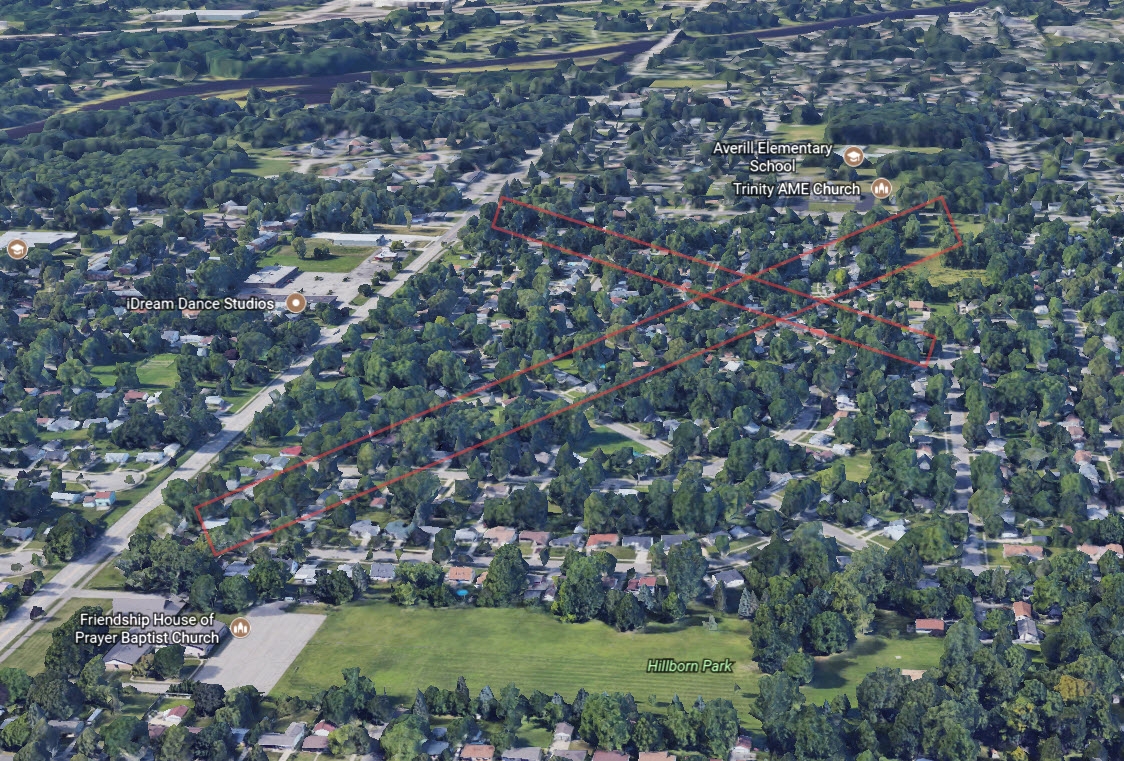
Are you referring to the white area along the bottom? If so, I believe those are the plots along Sumpter- those were among the first to be built in Churchill Downs.
Excuse the super crude drawings, but I think that the red line is about where Lochmore is now, the green box is Hillborn Park today and the gold lines are Waverly heading north and Holmes heading east. I'm basing this on the guess that the area where the church is on Waverly today is what we see as the developed plot in the lower left quadrant of the archive. Totally could be an incorrect assumption though.
I love these old photos. My favorite group on FB is the Lansing Historical Society- I'm sure a lot of you follow it, but for those that don't, here's the link
https://www.facebook.com/groups/137660544586/
I am sure that most people who read this would know, but I just subscribed to the archives site of the Lansing State Journal. I was looking for stories about my older brother, he was a great athlete at Sexton in the early 60's. On the site you can look up and read the paper from any day in their archive. I did found the downloads to be very small when printed if you try to download a whole page. Anyway it is very interesting and reminds me how great the old LSJ was, in those days it was a big part of life in Lansing.
I should look into that. I did the trial for newspapers.com but it's pretty expensive. I bet the LSJ version is cheaper.
Correct, MichMatters. Walter and his wife had two grandsons, Mark and Scott and that's how the SE Lansing development got the name, 'Marscot'. On another historical note, Walter Neller also founded 'Lansing Civic Players'.
Marscot is off Miller Rd, between Pennsylvania and Aurelius
I've never seen a picture of that building in the 100 south block, it would certainly be a nice one to still have around. If that facade does still exist under there it would be very nice to see it restored but I also doubt it's still under there since I think the facade that's on there now is a modernization of a previous modernization. On the plus sides if there's nothing worth saving then that building is one of the few sites on Washington Square that could host a large development.
In the 60's this was the site of the Jupiter Department Store, which we called Jupiter's. It was a five and dime kind of store. There was a lot of that type of store downtown. In this photo, you can see the first idea they had for malling S. Washinton Ave... They took out the parking meters and put up attended payment booths at one end of each block. It was not popular, as you can see this store had just closed.
Those awful tracks. The Lansing Plan recommended that the city change it so that those tracks weren't at grade- but obviously that never was taken up.