It started as bulldozed red-tags, but it definitely looks like more now. I am reaching out to Adam Hussein for more details, since there's no signs advertising what is happening there.
According to Adam Hussein, townhomes are going into that area. He said that the parcels were combined and already zoned multi-family- so the developer didn't need to come to the council for anything.
He's going to try to have a meeting with the builder to learn more about the plan- we was as surprised as I was that something that large was being built without any type of announcement.
Weird, because the maps are still showing the area zoned as single-family homes. I'll do some research into this with some of my contacts, too. Good to hear for increased density along this stretch of road, though.
Okay, so apparently this is a 30-unit townhome development and just on the parcel immediately east of the eastern end of Simkin Drive (1921 West Holmes). If anything was demolished east of this parcel, it's for something else, as those lots would have to be rezoned and combined to fit something like this.
Also, this lot is, indeed, zoned for multi-family (lowest density multi-family), but because the color assigned to it on the zoning maps are so similar to the lowest density single-family home district, I thought it was zoned single family. Though, the southern end of the lot that isn't being built on is actually zoned single family.
The city website actually has a site plan scanned for this one. See if this link works:
It's 10 unit buildings on the west, south and east sides of the lot with a central parking courtyard. Looks like they got their building permit at the end of November. Anyway, glad to see new construction down this way, and really that a ridiculously large parcel (2 acres in the middle of the city) that would had only held one house as if it were a farm house somewhere out in the country is being used for a more urban usage.
This is good to hear! I'm glad it's not combining all the parcels....I think that would've made too homogenous of a development. I haven't spent much time in this part of town, but exploring in google maps it looks like there are some other multifamily buildings nearby, interspersed with a cool old brick school building (for sale) and old country homes and liquor stores. Very strange mix. But I totally agree -- added density here is a good thing.
The intersection (Pleasant Grove & Holmes) is a problem area, to put it kindly. Not a whole lot of murders, shootings and rapes - though it's not unheard of - but lots of loitering and open-air alcohol and drug sales/use. In fact, the city council is currently in a protracted battle with the Holmes Plaza owners over his property, which he's promised to helped clean-up. I think they've actually been too hard on him, but this is all just to say that it's not a nice area and hasn't been in years.
Hopefully, between the council's focus on the area, the new pocket-park, Beacon Field Southwest, and this new development - which I was surprised to hear about given the reputation of the area - it's finally turning a corner. I really think urban planning is an often highly underappreciated aspect of why and area turns out like it does. In this case, the iterminably long blocks and long lots didn't help; this kind of stuff helps foster anti-social behaviors. Putting in the bike lanes a year ago - which has the effect of slowing down traffic - was kind of the start of reworking this area. But I think the area needs to be split up more (more blocks) to make it more walkable and social.
It's always been a weird area to me, because even the areas along West Jolly Road further south and developed later were developed better. I'd run Christiansen Street up to Holmes just east of this development. And Bristol Street should have ran all the way up to Holmes, but that never happened. Simken probably should have been connected to this development, too, to allow another outlet for the internal traffic (auto and pedestrian).
FWIW I agree about the odd planning there. It's like the planners forgot to this area on the march south, it felt semi-rural even though it's surrounded by subdivisions.
I'd be curious to better know the history of the area. I'm pretty sure it was more or less rural at one time, you can tell that some of the buildings and houses are older than most of the neighborhoods around there. I imagine that intersection was a little more developed because of the school being there.
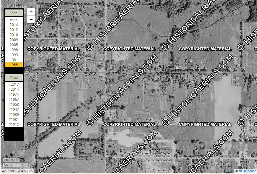
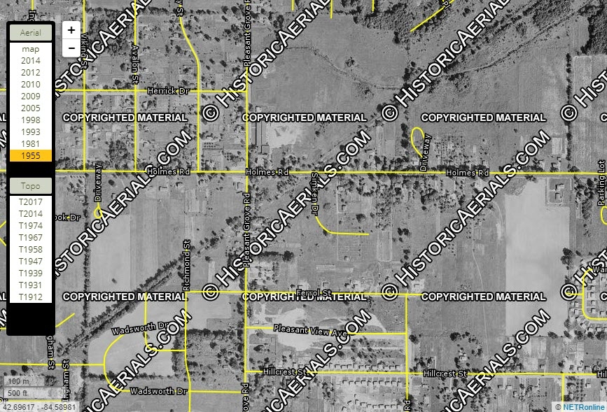
The area was previously the Pleasant Grove school district, and from what I've gathered it was rural. In fact, a house stands today on Pleasant Grove/Reo that at one point was part of a farm. I saw the pics of the house then versus today and it was really interesting. Development seems to have started in the 50s. Attached is an aerial from 1955 and a second with the current road location and names.
This is fascinating. Thanks for digging this up! I was wondering why the homes on Holmes (haha) on the northside of the road -- you can see that the land drops off behind them from the road to the back (northside) of the properties -- it must be this was the drop down into the stream bed floodplain below. You can see the stream to the north that must have been buried at some point?? I'm assuming the angled line is railroad tracks, I wonder if there is a bridge where they cross this stream?
Comments
It started as bulldozed red-tags, but it definitely looks like more now. I am reaching out to Adam Hussein for more details, since there's no signs advertising what is happening there.
According to Adam Hussein, townhomes are going into that area. He said that the parcels were combined and already zoned multi-family- so the developer didn't need to come to the council for anything.
He's going to try to have a meeting with the builder to learn more about the plan- we was as surprised as I was that something that large was being built without any type of announcement.
Weird, because the maps are still showing the area zoned as single-family homes. I'll do some research into this with some of my contacts, too. Good to hear for increased density along this stretch of road, though.
Okay, so apparently this is a 30-unit townhome development and just on the parcel immediately east of the eastern end of Simkin Drive (1921 West Holmes). If anything was demolished east of this parcel, it's for something else, as those lots would have to be rezoned and combined to fit something like this.
Also, this lot is, indeed, zoned for multi-family (lowest density multi-family), but because the color assigned to it on the zoning maps are so similar to the lowest density single-family home district, I thought it was zoned single family. Though, the southern end of the lot that isn't being built on is actually zoned single family.
The city website actually has a site plan scanned for this one. See if this link works:
https://bsaonline.com/CD_PropertySearchV2/DisplayAttachment?attachmentGuid=3f2937b4-a17f-47ea-99bc-a9a500fb4a54&linkFromGuid=ee225c7b-ccb8-458b-a5f7-a9120083f5bb&linkFromType=56&uid=384
It's 10 unit buildings on the west, south and east sides of the lot with a central parking courtyard. Looks like they got their building permit at the end of November. Anyway, glad to see new construction down this way, and really that a ridiculously large parcel (2 acres in the middle of the city) that would had only held one house as if it were a farm house somewhere out in the country is being used for a more urban usage.
This is good to hear! I'm glad it's not combining all the parcels....I think that would've made too homogenous of a development. I haven't spent much time in this part of town, but exploring in google maps it looks like there are some other multifamily buildings nearby, interspersed with a cool old brick school building (for sale) and old country homes and liquor stores. Very strange mix. But I totally agree -- added density here is a good thing.
The intersection (Pleasant Grove & Holmes) is a problem area, to put it kindly. Not a whole lot of murders, shootings and rapes - though it's not unheard of - but lots of loitering and open-air alcohol and drug sales/use. In fact, the city council is currently in a protracted battle with the Holmes Plaza owners over his property, which he's promised to helped clean-up. I think they've actually been too hard on him, but this is all just to say that it's not a nice area and hasn't been in years.
Hopefully, between the council's focus on the area, the new pocket-park, Beacon Field Southwest, and this new development - which I was surprised to hear about given the reputation of the area - it's finally turning a corner. I really think urban planning is an often highly underappreciated aspect of why and area turns out like it does. In this case, the iterminably long blocks and long lots didn't help; this kind of stuff helps foster anti-social behaviors. Putting in the bike lanes a year ago - which has the effect of slowing down traffic - was kind of the start of reworking this area. But I think the area needs to be split up more (more blocks) to make it more walkable and social.
It's always been a weird area to me, because even the areas along West Jolly Road further south and developed later were developed better. I'd run Christiansen Street up to Holmes just east of this development. And Bristol Street should have ran all the way up to Holmes, but that never happened. Simken probably should have been connected to this development, too, to allow another outlet for the internal traffic (auto and pedestrian).
Great information @MichMatters thanks!
FWIW I agree about the odd planning there. It's like the planners forgot to this area on the march south, it felt semi-rural even though it's surrounded by subdivisions.
I'd be curious to better know the history of the area. I'm pretty sure it was more or less rural at one time, you can tell that some of the buildings and houses are older than most of the neighborhoods around there. I imagine that intersection was a little more developed because of the school being there.
The area was previously the Pleasant Grove school district, and from what I've gathered it was rural. In fact, a house stands today on Pleasant Grove/Reo that at one point was part of a farm. I saw the pics of the house then versus today and it was really interesting. Development seems to have started in the 50s. Attached is an aerial from 1955 and a second with the current road location and names.

This is fascinating. Thanks for digging this up! I was wondering why the homes on Holmes (haha) on the northside of the road -- you can see that the land drops off behind them from the road to the back (northside) of the properties -- it must be this was the drop down into the stream bed floodplain below. You can see the stream to the north that must have been buried at some point?? I'm assuming the angled line is railroad tracks, I wonder if there is a bridge where they cross this stream?